The sea floor was mostly within a range of two centimeters flats with a few bumps that were less.
using a remote sensing technology is an advantage because it is more accurate, you're not measuring it yourself. using a stretched y-axis the numbers are closer together and a smaller range of numbers instead of graphing a lot of numbers and having a very tall graph.
 flat abyssal plain;
flat areas on the deep ocean floor.
underwater seamount or guyot;
guyot; a flat topped underwater mountain that is wave formed from previous islands.
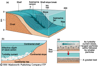
a continental break shelf slope and rise;
continental shelf; the underwater extension of the continental land mass. on the right
submarine canyon on shelf;
canyon formations that are a result of water flow scouring typically due to a river outlet with the canyons normally found on the continental shelf. on the right
mid ocean ridge;
a long, seismically active submarine ridge system situated in the middle of an ocean basin and marking the site of the upwelling of magma associated with seafloor spreading. An example is the Mid-Atlantic Ridge.
A trench artic island arc system;
a volcanic chain parallel with the ocean trench, a volcanic string of islands
https://www.google.com/search?q=a+flat+abyssal+plain%3B&source=lnms&tbm=isch&sa=X&ei=sl1qUrD-C82HkQezlIGIAg&ved=0CAcQ_AUoAQ&biw=1366&bih=652#q=continenatl+shelf+submarine+canyon+&tbm=isch&facrc=_&imgdii=_&imgrc=BGEwDn2PpKTsRM%3A%3B8bQdeOhpQ61GCM%3Bhttp%253A%252F%252Fwww.cliffshade.com%252Fcolorado%252Fimages%252Fcontinental_margin2.gif%3Bhttp%253A%252F%252Fwww.cliffshade.com%252Fcolorado%252Frocks.htm%3B406%3B274
https://www.google.com/search?q=a+flat+abyssal+plain%3B&source=lnms&tbm=isch&sa=X&ei=sl1qUrD-C82HkQezlIGIAg&ved=0CAcQ_AUoAQ&biw=1366&bih=652#q=continenatl+shelf+&tbm=isch&facrc=_&imgdii=_&imgrc=2WFhLSoLLWm-LM%3A%3BzdnNE3CSSxM6SM%3Bhttp%253A%252F%252Fwww.onr.navy.mil%252Ffocus%252Focean%252Fimages%252Fregions%252Fcontinental.gif%3Bhttp%253A%252F%252Fwww.onr.navy.mil%252Ffocus%252Focean%252Fregions%252Foceanfloor2.htm%3B456%3B180
