Explain what causes Earth's uneven heating, and contrast angled light rays with direct light rays. Reference a model that helps clarify this concept. Write an opinion statement about what you learned from the "Global Wind Patterns" activity.
the flashlight activity was interesting to see the way to look at a flashlight. we had batteries, a flashlight, and a piece of paper. it was an interesting way to show how the light reflects off of the paper. and when you tilt it to either side, it shows how the sun works on the earth with the sun.
Explain how and why the Earth's rotation affects the movement of air and water masses. Describe a model that helps people understand this. Define the carioles effect and the Hadley cells. Explain why most deserts are found at 30 degrees N or S latitude. Minimum four to six sentences.
Friday, December 6, 2013
Friday, November 22, 2013
TURTLE ISLAND PROJECT
this project was fun but also a challenge to make sure we had every little detail. we had to include many different things to make it work.
1. What special considerations did you have to make for the nesting sea turtle sites located on the barrier island? we had a wall set up behind the villas separating the sea turtles and the villas for their safety. is was a sea wall.
2. What special considerations had to be made when determining a good site for the proposed fishing pier?we didnt want to put the pier next to the habitats because we didnt want to kill them
3. What could be some of the potential problems that might arise from the proposed golf course? Propose some of the ways in which the impacts can be reduced. we made to man developments and made them to large so we had to cut down
4. What are the economic benefits to the community of Loggerhead County if the development was done with the least amount of environmental impact? we would have more of an ecosystem
5. Describe three ways in which humans negatively impact coastal ecosystems such as the one you are working on with Loggerhead Barrier Island. humans are building on wildlife everyday and killing what we need to live our oxygen supply. h2o
6. How can maintaining natural vegetation help us to reduce the damage caused by oceanic events such as hurricanes, tsunami and continued beach erosion?
natural vegetation is the best kind of resource.

7. After listening to the other groups make their presentations, were there any ideas they had you would have used if you had though about it before-hand? You should list at least three different ideas and indicate why their idea is actually better for the environment than yours. make things smaller work on the scale. and save the wildlife and make them separate from us
Friday, November 15, 2013
A beach by another name
A.
Volcanic coast, primary
B.
Primary, glacier
C.
Primary, glacial
erosion
D.
Secondary, coastal erosion
E.
Primary, barrial island
F.
Secondary, coastal plain
G.
Secondary, costal plain
H.
Primary, nonmarine
I.
Secondary, mangrove coast
J.
Secondary, fault line coast
K.
Primary, decomposition
L.
Primary shore lines
M.
Primary coastal plain
N.
Primary, earthquakes
O.
Secondary, land erosion
P.
Secondary, wave cut beach
Q.
Secondary, land fall
R.
Primary, steep glaciers
Friday, November 1, 2013
SAND
Bonaire: The color of the minerals in the sand were clear, there was no magnetite, it was very small, it was moderatly sorted.
Hampton: The color of the sand is tan and pink. there was no magnitite in the small sand, and was very well sorted. these minerals were rocky
Bahamas:The colors of the sand are clear and white and they are very small and rocky. these minerals are well sorted.
Red Rock Canyon: The colors of the sand are a white clear color and red. And are very small and rocky. the minerals are very well sorted.
PEI: The colors of this sand is white and red, there is no magnetite and the small rocky sand is very well sorted.
Niles: The colors of this small non magnetite sand are clear and tan! these minerals are poorly sorted and subrounded.
Key West: The color of this sand is Clear almost white. these small minerals are poorly sorted and subrounded.
Maui: The color of these small minerals are orange and white. they are well rounded and very well sorted and are basically little rocks.
\
The two sands i chose to compare were Maui and Hampton beach. Maui is part of Hawaii and i have never seen the sand before until under a microscope. Hampton and Maui both do not have magnitite and they are both different colors. Maui are little rocks that are red, and orange. and Hampton is a tan and pink color. They both are very well sorted but Maui is a little more sorted.
Friday, October 25, 2013
SOUNDING THE SEA ; A STUFY IN BATHYMETRIC MAPPING
analysis;
The sea floor was mostly within a range of two centimeters flats with a few bumps that were less.
using a remote sensing technology is an advantage because it is more accurate, you're not measuring it yourself. using a stretched y-axis the numbers are closer together and a smaller range of numbers instead of graphing a lot of numbers and having a very tall graph.
 flat abyssal plain;
flat areas on the deep ocean floor.
underwater seamount or guyot;
guyot; a flat topped underwater mountain that is wave formed from previous islands.
a continental break shelf slope and rise;
continental shelf; the underwater extension of the continental land mass. on the right
submarine canyon on shelf;
canyon formations that are a result of water flow scouring typically due to a river outlet with the canyons normally found on the continental shelf. on the right
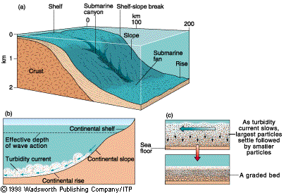
mid ocean ridge;
A trench artic island arc system;
a volcanic chain parallel with the ocean trench, a volcanic string of islands
https://www.google.com/search?q=a+flat+abyssal+plain%3B&source=lnms&tbm=isch&sa=X&ei=sl1qUrD-C82HkQezlIGIAg&ved=0CAcQ_AUoAQ&biw=1366&bih=652#q=continenatl+shelf+submarine+canyon+&tbm=isch&facrc=_&imgdii=_&imgrc=BGEwDn2PpKTsRM%3A%3B8bQdeOhpQ61GCM%3Bhttp%253A%252F%252Fwww.cliffshade.com%252Fcolorado%252Fimages%252Fcontinental_margin2.gif%3Bhttp%253A%252F%252Fwww.cliffshade.com%252Fcolorado%252Frocks.htm%3B406%3B274
https://www.google.com/search?q=a+flat+abyssal+plain%3B&source=lnms&tbm=isch&sa=X&ei=sl1qUrD-C82HkQezlIGIAg&ved=0CAcQ_AUoAQ&biw=1366&bih=652#q=continenatl+shelf+&tbm=isch&facrc=_&imgdii=_&imgrc=2WFhLSoLLWm-LM%3A%3BzdnNE3CSSxM6SM%3Bhttp%253A%252F%252Fwww.onr.navy.mil%252Ffocus%252Focean%252Fimages%252Fregions%252Fcontinental.gif%3Bhttp%253A%252F%252Fwww.onr.navy.mil%252Ffocus%252Focean%252Fregions%252Foceanfloor2.htm%3B456%3B180
The sea floor was mostly within a range of two centimeters flats with a few bumps that were less.
using a remote sensing technology is an advantage because it is more accurate, you're not measuring it yourself. using a stretched y-axis the numbers are closer together and a smaller range of numbers instead of graphing a lot of numbers and having a very tall graph.
flat abyssal plain;flat areas on the deep ocean floor.
underwater seamount or guyot;
guyot; a flat topped underwater mountain that is wave formed from previous islands.
a continental break shelf slope and rise;
continental shelf; the underwater extension of the continental land mass. on the right
submarine canyon on shelf;
canyon formations that are a result of water flow scouring typically due to a river outlet with the canyons normally found on the continental shelf. on the right
mid ocean ridge;
a long, seismically active submarine ridge system situated in the middle of an ocean basin and marking the site of the upwelling of magma associated with seafloor spreading. An example is the Mid-Atlantic Ridge.
A trench artic island arc system;
a volcanic chain parallel with the ocean trench, a volcanic string of islands
https://www.google.com/search?q=a+flat+abyssal+plain%3B&source=lnms&tbm=isch&sa=X&ei=sl1qUrD-C82HkQezlIGIAg&ved=0CAcQ_AUoAQ&biw=1366&bih=652#q=continenatl+shelf+submarine+canyon+&tbm=isch&facrc=_&imgdii=_&imgrc=BGEwDn2PpKTsRM%3A%3B8bQdeOhpQ61GCM%3Bhttp%253A%252F%252Fwww.cliffshade.com%252Fcolorado%252Fimages%252Fcontinental_margin2.gif%3Bhttp%253A%252F%252Fwww.cliffshade.com%252Fcolorado%252Frocks.htm%3B406%3B274
https://www.google.com/search?q=a+flat+abyssal+plain%3B&source=lnms&tbm=isch&sa=X&ei=sl1qUrD-C82HkQezlIGIAg&ved=0CAcQ_AUoAQ&biw=1366&bih=652#q=continenatl+shelf+&tbm=isch&facrc=_&imgdii=_&imgrc=2WFhLSoLLWm-LM%3A%3BzdnNE3CSSxM6SM%3Bhttp%253A%252F%252Fwww.onr.navy.mil%252Ffocus%252Focean%252Fimages%252Fregions%252Fcontinental.gif%3Bhttp%253A%252F%252Fwww.onr.navy.mil%252Ffocus%252Focean%252Fregions%252Foceanfloor2.htm%3B456%3B180
Friday, October 4, 2013
Oceanography Field Trip
 I went on a field tip in sailsbery beach. We went on a boat an we sailed out to hapmton beach and did labs that had to do with the ocean. There were five different labs that we were assigned to do. in one lab you started out looking at thing that live on the bottom of the ocean for instense sea annenmies muscles, skelton shrimp, sea skates, we got to pick up and feel the sea skate.
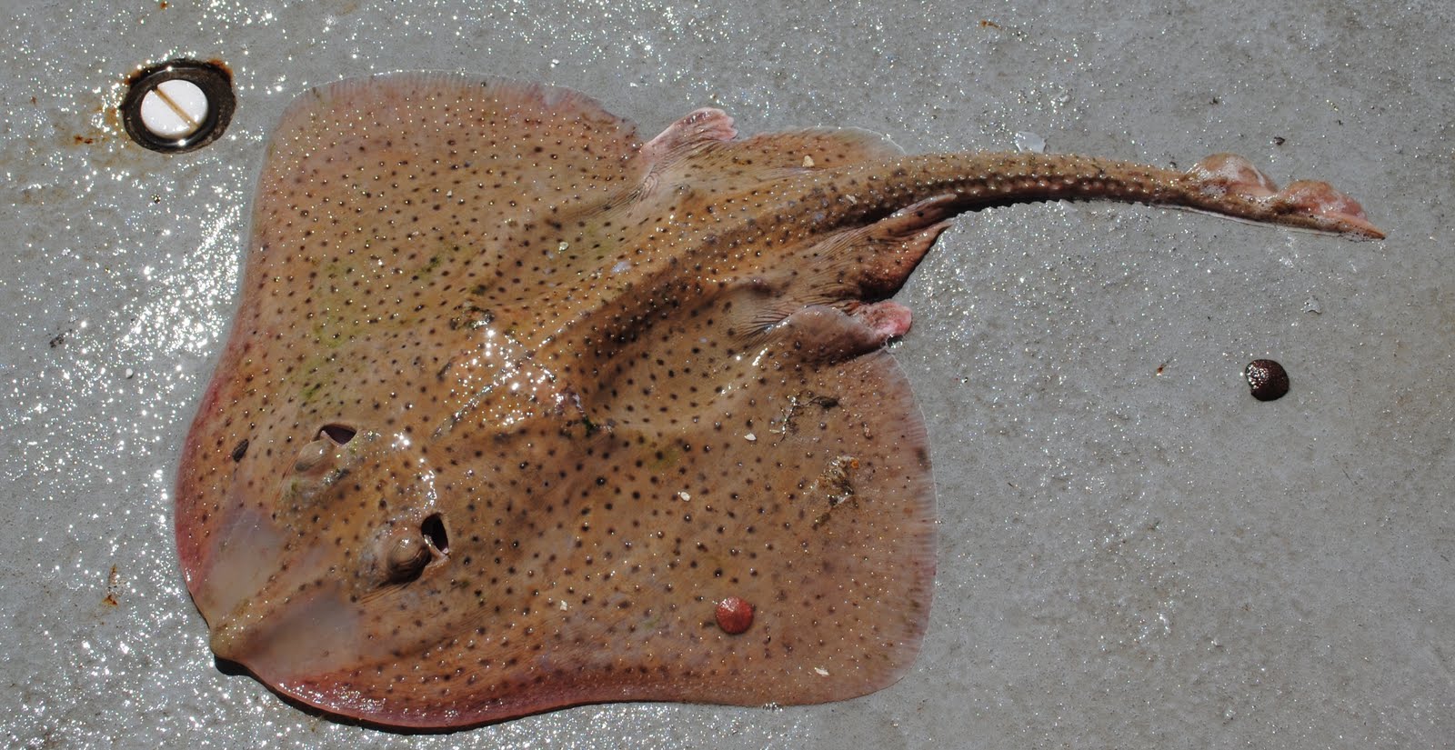
(A sea skate is to the right)
In the second lab we had to capture plankton from the bottom off the side of the boat, after we took them up we had to put them into little test boxes and look at the through magnifying glasses, they’re are microscopic and can grow up to six to eight feet long.
In the third lab we had to learn all about how the fish and other mammals do and what they eat at different times of the year and it was extemely factual.
In the fourth lab we had to take compasses and pick point around us to navigate where we were and when we were done drawing the lines on the aps of certain points we then got to see a little triangle an that’s where we were out in the ocean! In the fifth lab we had to use a device that apture a good amount of water and use the water to find the density, sailinty, the tempature, the pH level. Out of all of those labs i learned so much that i never knew was in the ocean, that you could find out about the ocean and so much more. we then went to the beach and i learned what a wrack line is, a wrack line is where the last high tide came up to on the beach and left a bunch of dried up sea weed, cigarettes, bootle caps, and shells. This field trip was a great expiernce and im glad that i had the oppertunity to go with such good people on an amazing day!
Yesterday October 3, 2013
Friday, September 20, 2013
Molasses Spill Hawaii
The Difficulties of Underwater Research
 There was a huge molasses spill in Hawaii do to a Matson cargo ship. This is problem for people researching and mammals and other living organisms under the ocean. It was killing coral reefs, and killing many many fish. the molasses sucked out the of the water. The ocean is usually a greenish color due to the algae in the water and now because of this spill the water is the color of cola, almost like it is laminated to the ocean floor. almost all living creatures are living in holes attempting to survive from this tragedy."I've never seen anything like this. We had a large sewage spill six or eight years ago. It was a stinky mess, but nothing like this." - Tanya Basu
".... An accident is an accident and no company would want an accident."- Beth Kerner
She is right, it was nobody's fault this happen, and I'm sure that nobody would want this or wish that this to have happened but no it has. People learn from their mistakes and can now take safety precautions to prevent anything like this happening again, from hurting innocent creatures and harming their environment.
www.examiner.com -
derbycitynaturals.com -
Friday, September 13, 2013
Oceanography
WHY EXPLORE THE OCEANS?

The Chinese made ships that towered over others, they had more technology and more advancements. Sir Francis Drake was the first Englishmen to sail around the world in 1580. They noted that you could predict in the Atlantic by the phases of the moon. Eratosthenes calculated the earths circumference and invented longitude and latitude.
Friday, September 6, 2013
CLASS
- I wanted to take Oceanography because I wanted to learn more about the ocean life and what was in it.
- One thing I hope to gain from this course is more information about the ocean world.
- Science is everyday life and it is very interesting to see how it all works and what is in it.
Subscribe to:
Posts (Atom)